
METEOROLOGY –WEATHER PATTERNS MIDDLE LEVEL CLOUDS


METEOROLOGY –WEATHER PATTERNS PRECIPITATION
CAUSES 1.Condensation/Deposition: grows in weight until it falls 2.Coalescence: Big drops fall thru and absorb smaller droplets. 3.Ice-Crystal Process at mid-high altitudes where water can exist below freezing as evidenced by “Super Cooled Droplets”that can exist down to -40 C.
TYPES
DRIZZLE (DZ) and RAIN (RA)
Drizzle (less than .02 inches in diameter
Rain (equal or greater than .02 inches.
Virga –Rain that evaporates before reaching the ground.
Precipitation induced fog: evaporation from falling rain (verydense)

ICE PELLETS (PL) and HAIL (GR)
Ice Pellets usually are associated with inversions when precipitation at the higher level falls down to lower temperatures below and beginto freeze into small ice pellets. EXPECT FREEZING RAIN ABOVE !!! Also-most often associated with warm fronts rather than cold fronts.
 Hail is caused by vertical cloud development (cumulonimbus) and ice grows to such a size as cannot be help up any longer. Can get up to 5inches –1 ½ pounds in weight.
SNOW (SN)
Not the same as Ice Pellets. Flat –do not bounce or shatter on impact. They can exist in high level cloud formations within cirrus and are called “Fallstreaks.” ---------------------------------→

Air masses change in speed, temperature & depth when moving out of source region.


METEOROLOGY –WEATHER PATTERNS HIGH LEVEL CLOUDS
METEOROLOGY –WEATHER PATTERNS CUMULOUS CLOUDS (Vertical Development)
CAUSES 1.Condensation/Deposition: grows in weight until it falls 2.Coalescence: Big drops fall thru and absorb smaller droplets. 3.Ice-Crystal Process at mid-high altitudes where water can exist below freezing as evidenced by “Super Cooled Droplets”that can exist down to -40 C.
TYPES
DRIZZLE (DZ) and RAIN (RA)
Drizzle (less than .02 inches in diameter
Rain (equal or greater than .02 inches.
Virga –Rain that evaporates before reaching the ground.
Precipitation induced fog: evaporation from falling rain (verydense)
METEOROLOGY –WEATHER PATTERNS PRECIPITATION
ICE PELLETS (PL) and HAIL (GR)
Ice Pellets usually are associated with inversions when precipitation at the higher level falls down to lower temperatures below and beginto freeze into small ice pellets. EXPECT FREEZING RAIN ABOVE !!! Also-most often associated with warm fronts rather than cold fronts.

SNOW (SN)
Not the same as Ice Pellets. Flat –do not bounce or shatter on impact. They can exist in high level cloud formations within cirrus and are called “Fallstreaks.” ---------------------------------→
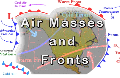
METEOROLOGY –WEATHER PATTERNS AIR MASSES
AIRMASS Body of air with uniform temperature and moisture, ORIGINATING from land “Continental”or from water “Maritime”

HEATED FROM BELOW the air mass is modified to become unstable with “lake effect snows”and snowfall on “lee”side of mountains.
Conversely, air masses COOLED FROM BELOW can result in a stable, condensation effects with statoform clouds and fog.
METEOROLOGY –WEATHER PATTERNS FRONTS
FRONT: A boundary between air masses having different temperature and moisture content. Often a “line of confrontation”with serious flying hazards.
TYPES
Cold Front: Colder air slips beneath and overtakes warmer air.
Warm Front: Warmer air rides above and overtakes cooler air.
Stationary Front: (no movement) cool and warm air coexist in same region.
Occluded Front: Fast moving cool air mass catches and merges with the warm front often causing a low pressure area to form to the north.
METEOROLOGY –COLD FRONTS
The leading edge of a cold air mass overtakes and replaces warmer air at the surface. Cold fronts generally move faster and have a steeper slope than warm fronts.
Winds/clouds/precipitation —Cold-front passage is characterized by a temperature decrease; by a wind shift from a southerly to a northwesterly direction; and, on occasion,by gusty winds. Convective clouds often develop in the warm air ahead of the front. The warm and wet ground behind the front generates low-level convection and fairweather cumulus in the cold air.
Fast-moving cold front —Very steep slopes and narrow bands of clouds, usually found ahead of the front. Showers and thunderstorms develop along the surface position, and a line of thunderstorms (squall line) frequently develops ahead of the front.
Slow-moving cold front —Less steep slopes and cloud systems that may extend far to the rear of the surface position of the front.
METEOROLOGY –WARM FRONTS
The leading edge of a warm air mass overtakes and replaces colder air. Denser cold air close to the surface forces the warm air to slide over it. This causes the front to lack direct push on the cold air, which in turn retreats slowly, resulting in a gentle frontal slope and a relatively slow-moving warm front.
Winds/clouds/precipitation —
Moist and stable air —Produces clouds that are stratiform and widespread over the shallow front. Precipitation is continuous and induces widespread stratus in the cold air.
Moist and unstable air—Produces widespread cloud masses in which altocumulus, cumulonimbus, and thunderstorms are embedded. Watch out for icepellets and freezing rain above.
STATIONARY AND OCCLUDED FRONTS
Stationary: “relatively”balanced between masses but incorporates whatever conditions exist below (sea –moisture, dry land –reduced moisture, etc.)
Warm-front occlusion—Occurs when the warmest air is under the cold front. When it overtakes the warm front, the less cold air rides over the colder air, andcool air replaces cold air at the surface. Cold-front occlusion—Occurs when the coldest air is under the cold front. When it overtakes the warm front, it lifts the warm front aloft, and cold air replacescool air at the surface.
You can learn by yourself with the material below:
- Pilot's Handbook of Aeronautical Knowledge [PHAK]
- Online Meteorology Guide
- Pilot's Handbook of Aeronautical Knowledge [PHAK]
- Online Meteorology Guide


Note: only a member of this blog may post a comment.